
news · 18 min
The River They Put Back
In the 1960s Florida straightened the Kissimmee into a ditch. Then it spent thirty years and close to a billion dollars undoing the work. The birds came back before the bulldozers left.
By The Editors ·
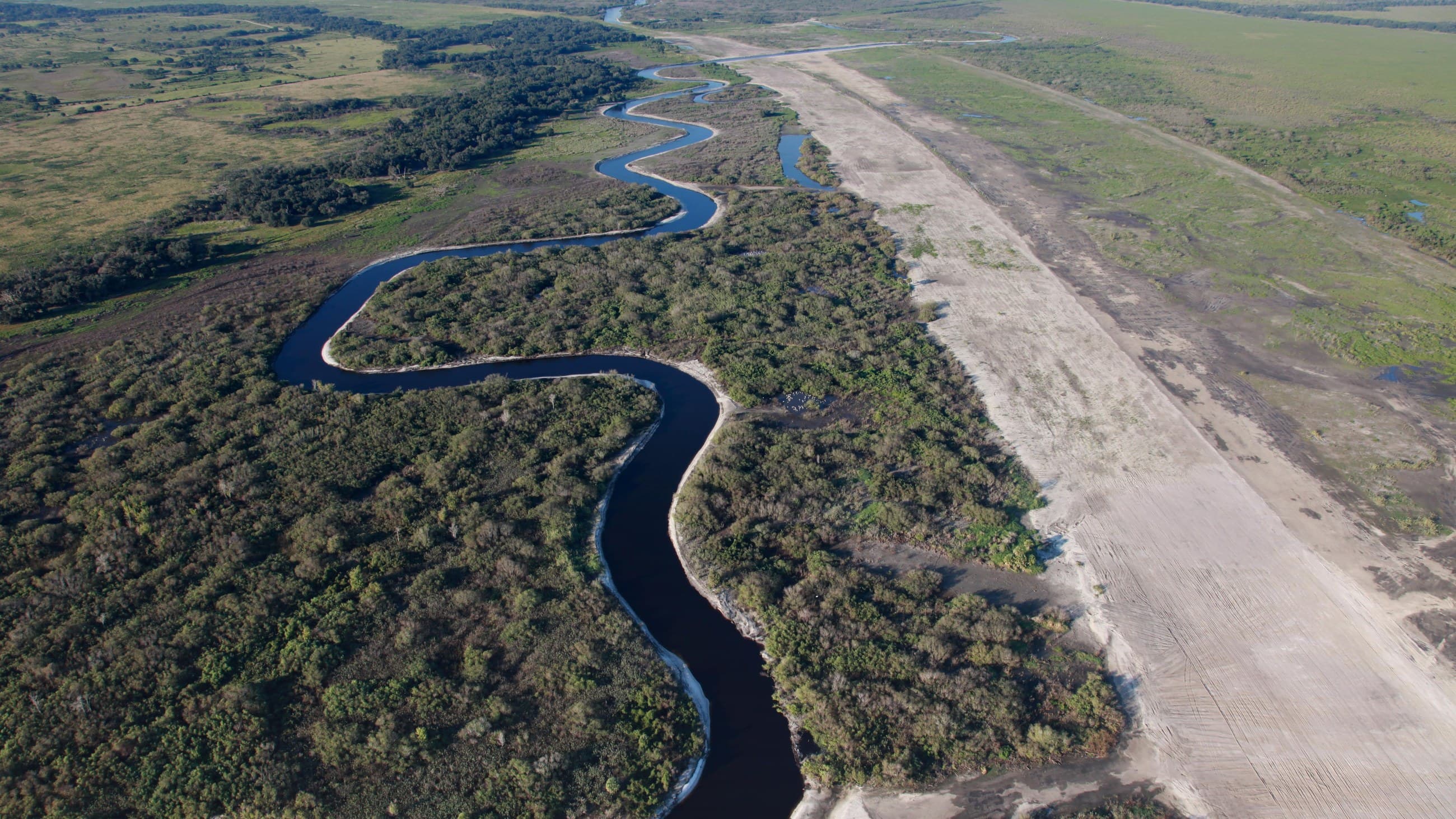
From the air the restored Kissimmee looks like a signature written next to a ruler. The river loops and doubles back through a dark green floodplain, and beside it, straight as a road, runs the pale scar of the canal that replaced it for forty years, now filled in with the same dirt that was dug out of it. Nobody planned to build both. Florida built the ruler first, decided it had been a mistake, and then spent longer putting the river back than it had spent taking it out.
This is the story of that mistake and its repair. It is worth telling at length because it is the one large piece of Florida water engineering that has been run in reverse, on purpose, with the results measured, and because the measurements are in. The South Florida Water Management District has been counting birds, fish, and oxygen on this river for a quarter century. What the numbers say is that a river, given back its floodplain, will do most of the rest itself, and that the parts it cannot do alone are the parts people are still arguing about.
The River as It Was
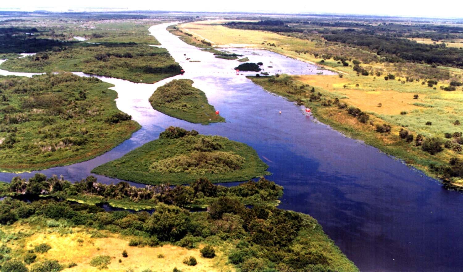
The Kissimmee begins in a chain of lakes south of Orlando, Tohopekaliga and Cypress and Hatchineha and, at the bottom of the chain, Lake Kissimmee, and from there it ran 103 miles south to Lake Okeechobee. It fell only about thirty-six feet in all that distance, from fifty-one feet above sea level at the lake outlet to fifteen at the big lake, which is to say it hardly fell at all. A river with that little slope does not cut a channel and stay in it. It wanders. The old Kissimmee meandered across a floodplain up to two miles wide, and in most years it left its banks and spread over the whole plain for anywhere from four to eleven months.
The engineers who later studied it worked out from the records of 1942 to 1960 that about ninety-four percent of the floodplain was under water more than half the time. This was not a flood in the sense of a disaster. It was the river's ordinary condition, a shallow sheet a foot or two deep moving slowly south through marsh, and it is why the valley held what it held. Audubon surveys between 1936 and 1959 recorded sixteen species of wading birds. State biologists counted thirty-five kinds of fish in 1957, with a largemouth bass fishery known well beyond Florida. Sixteen species of waterfowl wintered on the plain. Broadleaf marsh covered more than half of it and wet prairie most of the rest.
People used the river without changing it much. The Seminole lived along it, and the Second Seminole War came to its banks: Zachary Taylor built Fort Basinger on the Kissimmee in December 1837 on his way to the Battle of Lake Okeechobee, fought on Christmas Day. Cattle drovers pushed herds across the prairie to the Gulf at Punta Rassa. Then, in 1881, a Philadelphia saw manufacturer named Hamilton Disston bought four million acres of Florida for a million dollars, twenty-five cents an acre, and contracted with the state to drain the Kissimmee valley in exchange for half of whatever land he reclaimed. His dredges started that winter at the Okeechobee end, and by the time they were done there was a navigable channel from Lake Tohopekaliga down through the chain and the river to the Gulf. For a generation the Kissimmee was a steamboat route.
The boats had names like Roseada and Lillie and Bassinger, and three of them ran a weekly service from the town of Kissimmee down to the landing at Basinger, eighty miles by road and something like a hundred and sixty-five by water, because the river went everywhere before it went south. The round trip took about five days. They carried alligator hides and otter skins north and settlers and supplies south. The Kissimmee Valley Gazette told its readers in 1899 that there was no pleasanter way to spend a week, and that birds were in sight the whole way: ducks, coots, herons, cranes, limpkins, curlews, plume birds, and water turkeys without end.
The Ditch
What ended the old river was rain. In September and October 1947 two hurricanes crossed the peninsula a month apart and the Kissimmee basin went under. The district's own summary of the project puts the flooded area at 246,847 acres and the damage at more than a million dollars, and the country between Lake Cypress and Lake Kissimmee stayed under water for about eight months. Orlando and the towns around the lakes were growing, and they wanted it never to happen again.
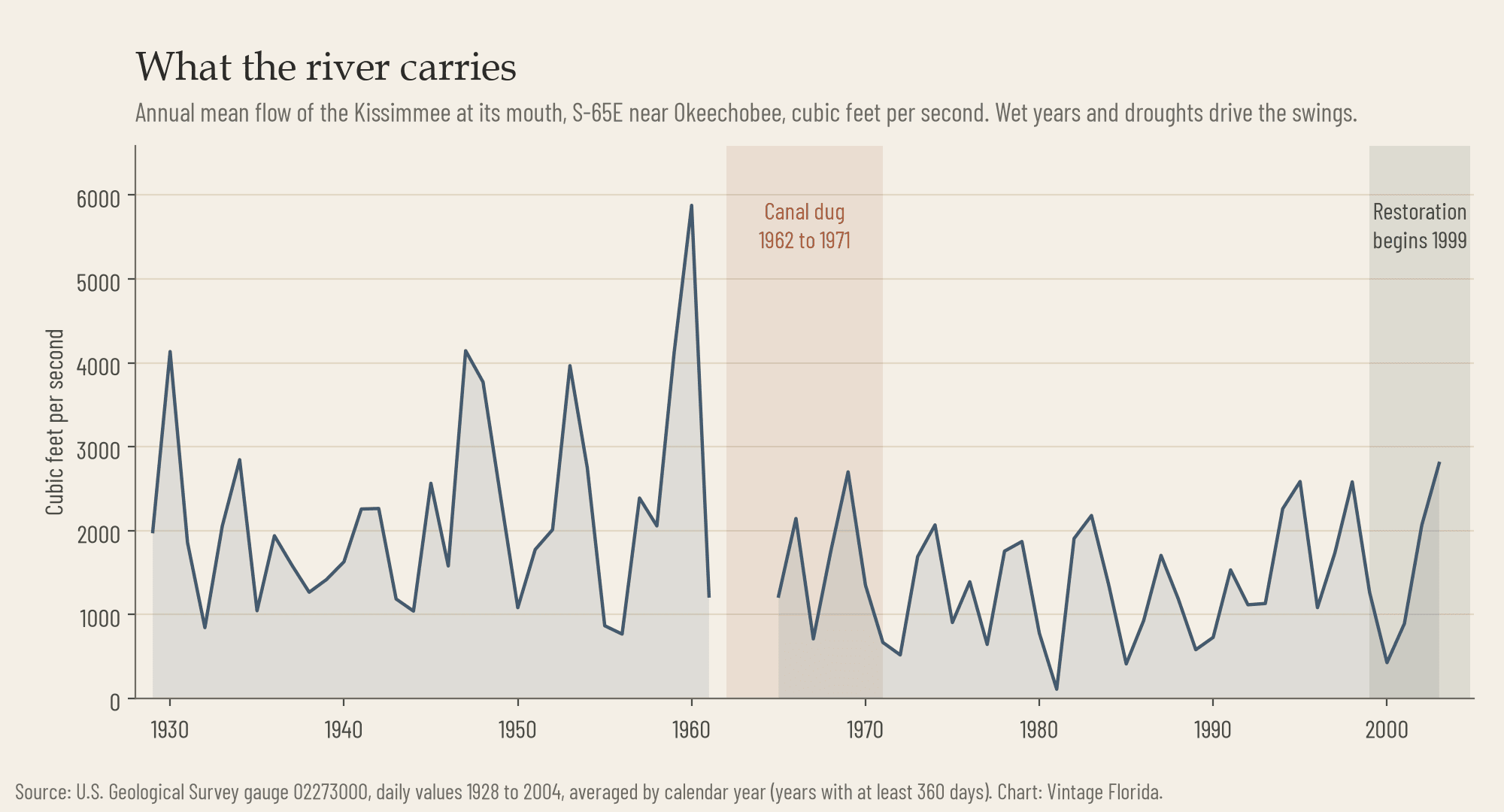
Congress answered in 1948 with the Central and Southern Florida Flood Control Project, the great plumbing of the state that also gave South Florida its canals and levees, and in 1954 it added the Kissimmee. The Corps of Engineers designed the work through the rest of the decade and dug it between 1962 and 1971. The result was the C-38 canal: fifty-six miles long, thirty feet deep, between ninety and three hundred feet wide, running down the valley in a line, with six water control structures that turned the river into a staircase of five pools. The canal took the water that used to take four to eleven months to pass through the marsh and moved it to Lake Okeechobee in days.
It worked as flood control. As a river it was a catastrophe, and the speed of the collapse is the part that is hard to credit now. Where the canal was cut straight through, about thirty-five miles of the old channel simply ceased to exist under the spoil. The rest of the meanders were left in place as dead-end oxbows off the canal, with no current. The floodplain drained. By the Corps' own 1991 accounting some 21,000 acres of wetland dried out; the water management district has used figures of 30,000 to 35,000. Ranchers put cattle on the dry marsh, and by one study forty-four percent of the drained floodplain became pasture.
The animals left with the water. Floodplain use by wintering waterfowl fell by ninety-two percent, a figure from a 1982 survey that the district still quotes. The number of bald eagle nesting territories dropped by seventy percent. The wading birds that had defined the valley thinned out and were replaced by cattle egrets, a bird that follows cows. In the stagnant oxbows the dissolved oxygen fell to levels that most fish cannot survive. Measurements in the summer of 1989 found under two milligrams per litre at the surface and under half a milligram three metres down. The bass fishery was, in the word the district used later, decimated, and the fish that took its place were gar and bowfin, which can breathe air.
The canal took water that used to spend four to eleven months in the marsh and moved it to Lake Okeechobee in days.
Thirty Years of Arguing
The complaints started before the dredges finished. In 1971, the year the canal was completed, the Governor's Conference on Water Management in South Florida came out of its sessions asking that the fish and wildlife of the Kissimmee basin be restored. The flood control district held its first public hearing on restoration the next year. In 1976 the legislature passed the Kissimmee River Restoration Act and created a coordinating council to figure out how. So the idea of putting the river back is almost exactly as old as the canal.
The man most associated with the idea was Arthur R. Marshall, a federal wildlife biologist who had run the Fish and Wildlife Service office at Vero Beach and who spent the 1970s and early 1980s making the case that South Florida's water had to be treated as one system from the Kissimmee lakes to Florida Bay. He sat on the water district's board and was forced off it. In April 1983 he circulated a paper titled, without much diplomacy, Florida Must Dechannelize the Lower Kissimmee River. That same year Governor Bob Graham launched the Save Our Everglades program, and restoring the Kissimmee was written into it as the first step, because whatever the river carried to Lake Okeechobee went on from there to everything south. Marshall died in February 1985. He never saw a yard of the canal filled.
What he did see was the first federal study, run from 1978 to 1985, conclude that restoration should not be a federal project because no version of it showed a net economic benefit. Flood control could be priced. A river could not. The state went ahead anyway with a demonstration on a small scale. Between 1984 and 1990 the district built three notched weirs across the canal in one pool to push water back into the old channel, let the pool level rise and fall with the seasons across about 2,700 acres, and watched. The weirs diverted up to sixty percent of the canal's flow. Wading bird densities doubled. Twenty-five species of fish turned up in the test pool against sixteen in a control pool downstream, and game fish went from forty-four percent of the fish weight to fifty-nine percent where the water moved.
A symposium in Orlando in 1988 set the terms for a full restoration: the river had to flow continuously, the floodplain had to flood seasonally, and the water had to rise and fall at something like the old pace. Engineers at the University of California at Berkeley built a physical model of the river to test whether refilled canal would hold or wash out, and found it would hold. Only one of the plans on the table met every criterion, the one that called for filling the canal itself, and in early 1990 the state endorsed it. In 1992 Congress put the Kissimmee into the Water Resources Development Act, and in 1994 the state and the Corps signed an agreement to split the cost evenly: the Corps would design and build, the district would buy the land and measure the results. Between March and August of that year the Corps filled in about three hundred metres of canal as a test. It held.
Filling It In
The plan was not to undo the whole canal. That was never on offer, because the towns around the upper lakes still needed the flood protection the canal gave them, and the last stretch above Lake Okeechobee had to stay a canal for the same reason. Of fifty-six miles, twenty-two in the middle would be filled. The old river channel that survived beside it would be reconnected, and where the canal had erased the channel entirely, a new one would be dug along the course the old channel had taken, which survived in aerial photographs from 1954.
The first phase ran from June 1999 to February 2001. Crews pushed about 9 million cubic metres of the original spoil back into the canal, filling seven and a half miles of it, and dug new river channel where the old one had been buried. In June 2000 they blew up the S-65B water control structure, the dam at the foot of the second pool. In July 2001 water flowed the length of that stretch of the old river for the first time in thirty years. The district's scientists had said the river would answer quickly. It did. Within a few seasons the organic layer on the river bottom, the residue of decades without current, was thinning and sandbars were forming again; by the Corps' 2021 accounting the muck was down seventy-one percent. The birds are the next section of this story.
The rest took twenty more years. Two shorter phases filled another six miles between 2006 and 2009. The last and longest stretch, eight and a half miles of backfill through the lower pools, required raising a railroad bridge, raising and rebuilding the U.S. 98 crossing, removing a second dam, and building a new weir to steer flow, and the final contracts on it were finished in 2021. On July 29 of that year, at the river, the Corps and the district declared the construction complete. Twenty-two miles of canal filled. More than forty miles of meandering river carrying water again. Around forty square miles of river and floodplain, some 20,000 acres of it wetland, put back under the seasonal flood. The district had bought just over 100,000 acres to make room for it. The cost, split between Washington and Tallahassee, was put at $980 million in the district's projections, and has been reported since as anywhere from $800 million to a little over a billion.
Shannon Estenoz, then the Interior Department's assistant secretary for fish and wildlife and parks, and a Floridian who had spent her career on the Everglades, put it in a way that no engineer would have: "It's special in that it's very wiggly, and all the wiggles are back."
What Came Back
The district set out twenty-five things it expected to happen if the restoration worked, from the oxygen in the water to the number of ducks in winter, and has published the count against them every year since in the South Florida Environmental Report. That habit is what makes the Kissimmee different from most restoration stories, which are usually told in adjectives. Here are the numbers.
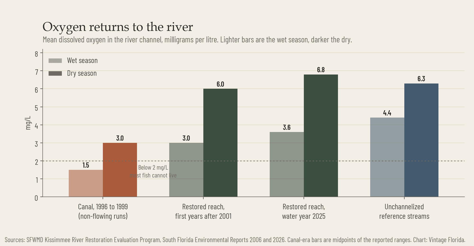
Oxygen first, because everything else depends on it. In the canal years the dead-end runs averaged under one to two milligrams of dissolved oxygen per litre in the wet season, and two to four in the dry. A study published in 2014 put the pre-restoration mean below two and the post-restoration mean at 4.7. In the most recent water year the restored channel averaged 3.6 in the wet season and 6.8 in the dry, against 4.4 and 6.3 in the unchannelized streams the district uses as a reference. The river breathes again.
The fish followed the oxygen. Largemouth bass and sunfish, which had been thirty-eight percent of the fish in the channel, were sixty-three percent by the Corps' 2021 accounting, and gar declined. In the spring of 2024 the district's electrofishing crews were catching eighty-six sunfish and bass an hour in the restored reach, most of them bluegill. Eight species of shorebird that had been absent from the canal reappeared, black-necked stilts among them, and stayed to breed.
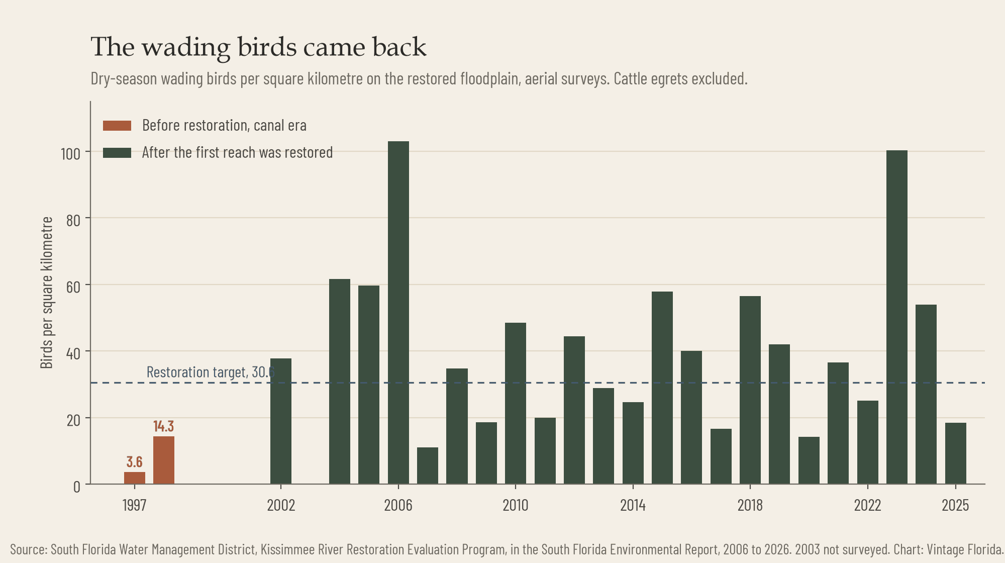
The wading birds are the headline. Before the first phase, aerial surveys of the reach counted 3.6 wading birds per square kilometre in the dry season of 1997 and 14.3 in 1998, not counting the cattle egrets that had taken over the pasture. The target for a restored river was 30.6 per square kilometre, sustained. Since 2002 the long-term average has run at 43.4. Some years have been extraordinary: 103 birds per square kilometre in 2006, and 100 in 2023. Some have been thin, and the most recent, 2025, was one of the thin ones at 18.5. Birds go where the water is in a given winter, and the district is candid that the survey-by-survey part of its target was not met that year. But the average is forty percent above the goal, and the reach that had almost no wading birds has been full of them for two decades.
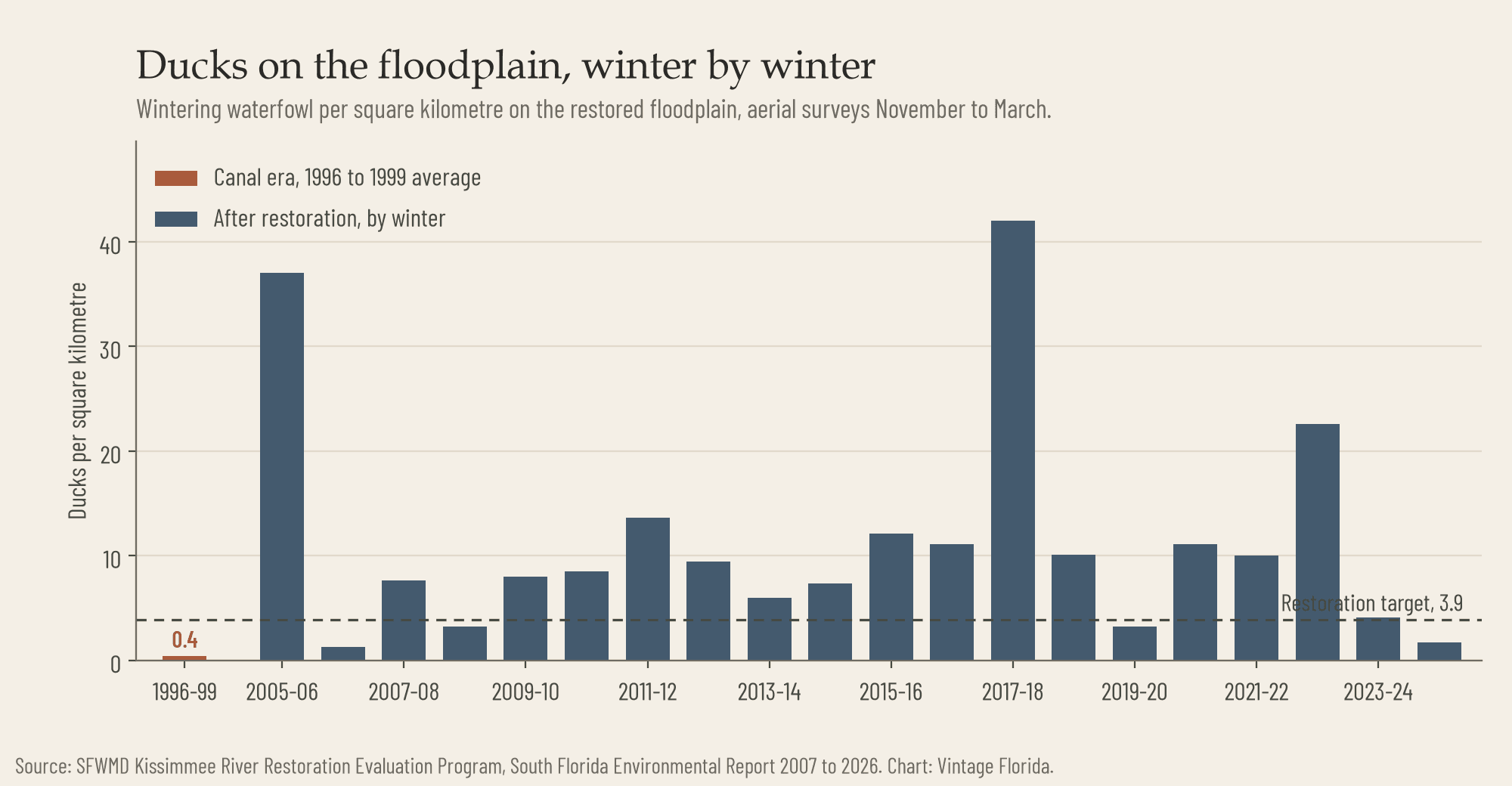
The ducks came back too, and the ducks show what the restoration has not fixed. In the canal years the reach averaged 0.4 ducks per square kilometre. The target was 3.9. The long-term average since restoration is 12.3, and the winter of 2017-18 saw 42. But the last two winters came in at 4.1 and 1.7, and the district counted only eight species in three years against a goal of ten. Ducks need the floodplain wet through the winter, and the floodplain has not been wet for long enough.
What Did Not
The honest accounting has three entries on the other side of the ledger, and the district publishes all three.
The first is the water schedule. Putting the meanders back does nothing unless the lakes upstream are allowed to send water down in the old pattern, high and slow through the wet season. That depends on raising the regulation levels of the headwater lakes by a foot and a half, which floods more shoreline than the towns on those lakes are used to. The change was supposed to be in place by 2014. The first increment, half a foot on the high side, finally took effect in August 2024, and the full schedule is now projected for 2027. Until it arrives, the floodplain gets its water in short bursts. The restoration's own target was a foot of water on the marsh for 210 days at a stretch. In twenty-three years that has never once been met, and the district has since rewritten the target to 110 days at four tenths of a foot. Even that has been met four times. The 2021 ceremony marked the end of the earthwork, not the end of the project.
The second is oxygen in the wrong season. When the summer floodplain drains back into the channel it carries rotting vegetation, and the river's oxygen crashes for weeks. Anoxic spells of twenty-five days or more have hit the restored reach in ten of the last twelve summers, every year since 2014 except 2018 and 2024. After the 2023 event the sunfish and bass count in the first reach fell by ninety-seven percent. The year before, in the oxygen sag that followed Hurricane Ian, residents at Kissimmee River Shores had watched dead fish drift past. The fish come back each spring, but the pattern is a sign that the river is still receiving too much water too fast off a floodplain that has not fully become marsh again. Broadleaf marsh has lost ground in the restored area to shrubs and to two exotic grasses, para grass and West Indian marsh grass, and the district burns a couple of thousand acres a year and sprays hundreds more to hold them.
The third is the lake at the bottom. Whatever the Kissimmee carries, Lake Okeechobee receives, and Okeechobee's problem is phosphorus. The lake has taken in roughly 400 to 500 metric tons of it a year over the past decade, against a legal target of 140, and the basins that drain through the lower Kissimmee are among the largest sources. A wet floodplain filters some of that, which was one of the arguments for the restoration, but most of the Kissimmee's length is still a canal, and the ranch land around the river still runs cattle. The district has not yet reported a measurement showing that the restored river sends the lake less phosphorus than the canal did. The district is designing a separate treatment marsh of about 4,800 acres in the lower basin to do the job the floodplain was hoped to do.
In twenty-three years the original flooding target has never once been met. The 2021 ceremony marked the end of the earthwork, not the end of the project.
And then there is the thing the project did for people rather than birds, which nobody has made much of. When Hurricane Ian crossed the state in September 2022, the river at the top of the restored reach was running close to 12,000 cubic feet per second by October 11, more than it has carried at any point since the restoration was finished. The floodplain took it. There was no failure of the backfilled canal. The one piece of damage, erosion that broke up part of the newly built weir, was patched by the next summer and fully repaired by July 2024. A river with its floodplain is flood control. It is only slower about it.
Going
The restored Kissimmee is a public river now in a way it was not when it was a canal. The state designated the Kissimmee River Blueway in June 2024, 76.5 miles of paddling trail from the lock at the bottom of Lake Kissimmee down to a county park on Lake Okeechobee. Paddlers pass through four locks, free, about fifteen minutes each, and the restored meanders run from about river mile 17 to mile 57. Nine primitive campsites along the way are free with a permit from the district, and the state wildlife agency's public use area covers more than 30,000 acres of the floodplain from State Road 60 south. Below about 1,400 cubic feet per second at the S-65A structure the current is easy; above that, the state's paddling guide advises waiting.
The best way to understand the place is from the Riverwoods Field Lab at Lorida, a station Florida Atlantic University runs with the district on the river's west bank, established in 1995, which takes school groups and the public out on the water. Next door, Kissimmee Prairie Preserve State Park holds some 54,000 acres of the dry prairie that used to border the river for most of its length, the largest piece of that landscape left anywhere, with more than a hundred miles of trail and Florida's first designated Dark Sky Park. Sandhill cranes still nest in its grass, as they did when the river beside it flooded every summer.
The old river is not entirely back. More than half of it is still a ditch and will stay one, the lakes upstream are still on a schedule written for flood control, and the marsh is still deciding what to grow. What has come back is the part that mattered most and cost least: the current, the oxygen, the sandbars, and the birds, which arrived within a couple of years of the water and have stayed for twenty. Florida does not have many stories in which it took something apart and then had the patience to reassemble it. This is the one. It is worth knowing that it took thirty years of argument, thirty more of work, the better part of a billion dollars, and one accident of the original design, which cut the canal straight through the meanders and left most of the old channel lying beside it, so that when the state changed its mind, the river was still there to be found.
Questions people ask
- What was the problem with the Kissimmee River canal?
- It drained the floodplain that everything depended on. The Army Corps of Engineers dug the C-38 canal between 1962 and 1971 for flood control, fifty-six miles long and thirty feet deep, in place of 103 miles of meandering river. Records from 1942 to 1960 show that about ninety-four percent of the floodplain had been under water more than half the time, a shallow sheet a foot or two deep moving slowly south through marsh, and that was what held the wading birds, the ducks and the fish. When the canal took the water, the wildlife went with it.
- Is the Kissimmee River restoration finished?
- The construction is. The plan was never to undo the whole canal, because the towns around the upper lakes still need the flood protection it gives them and the last stretch above Lake Okeechobee has to stay a canal for the same reason. Of fifty-six miles, twenty-two in the middle were filled in, in phases from June 1999 to 2021, and the final contracts were finished in 2021. The rest remains a canal.
- Did the wildlife come back to the Kissimmee?
- Largely, yes. Bass and sunfish, which had been thirty-eight percent of the fish in the channel, were sixty-three percent by the Corps' 2021 accounting, wading birds returned to the restored floodplain, and shorebird species that had been absent from the canal reappeared. Two things are not settled: oxygen in the restored reach still falls to dangerous levels in some summers, and the district has not yet shown that the restored river sends Lake Okeechobee less phosphorus than the canal did.